A very warm welcome to you and thanks for coming along with me on my next journey of the capital. Today’s walking adventure explores some of London’s lesser-known sights. I’ll begin my stroll in Lesnes Abbey Woods, continue through Thamesmead and then join the Thames Path. This will then take me past Royal Arsenal, Woolwich before ending my walk at the Thames Barrier. With a wonderful woodland, historical gem, magnificent military area and the architectural brilliance of a barrier awaiting me, let’s start discovering more of London!

My journey starts in Lesnes Abbey Woods, or sometimes known as Abbey Wood, which is an ancient woodland based in South-East London situated in the London Borough of Bexley. The name Lesnes derives from the ruins of Lesnes Abbey church, and we’ll discover that more as the walk goes on!


The wood’s date back to the Bronze Age and are full of wild bluebells and daffodils in the Spring, but all year round there’s a variety of beautiful trees, shrubs, plants and bushes spread around a vast area of woodland. In order to persevere its natural beauty, a local community group called the Lesnes Abbey Conservation Volunteers runs practical conservation events to help manage the woodland. The group was started in 1994 and is a registered environmental conservation charity run by the local people, and works closely with Bexley Council.


I’ve been very lucky on my walks to explore many woodlands, whether that’s Highgate Wood, Russia Dock Woodland, Dulwich Wood or the woods in Streatham Common – they all have their own unique elements and offer a real magical perspective. You definitely get this same feeling with Lesnes Abbey Wood, as it’s probably the largest woodland I’ve walked through, given that it also has the adjacent Abbey Wood next to it. But the huge woodland area just keeps going and going, and you uncover so many different parts of it, each offering their own breathtaking sights.


You sometimes forget you’re only a short train ride into central London, as it does have that countryside feel about it. One aspect about this woodland that I really enjoyed was just how peaceful it was and that you could walk for 10-15 minutes and not walk past anyone. I’m pretty sure you could walk around the entire woodland and still not discover everything, although, it’s sometimes quite hard to differentiate parts of the woodland as they all look so pretty!


I’ll now head out of the woodland to something of a historical gem which lies just outside of Lesnes Abbey Wood. When you walk down the path you see quite a few old stones and walls, but as you look more closer it’s the ruins of an old structure.

This piece of architectural brilliance is the remains of the old Lesnes Abbey, which is where the woodlands name derives from. After the Norman Conquest of 1066, the estate of Lesnes was owned by Bishop Odo, the half-brother of William the Conqueror and who was one of the most powerful men in Norman England. Lesnes Abbey was built by Richard de Luci in 1178. De Luci was the Chief Justiciar of England under Henry II, and it’s rumoured that he founded the abbey in repentance for his role in the murder of Thomas Becket. By 1525 it would become dissolved by cardinal Wolsey, which was partly due to the wider dissolution of monasteries in England. After this the monastic buildings were all pulled down, except for the lodging area.
In 1930 the London County Council bought the site and opened it to the public as a park. In 1986 control passed to the London Borough of Bexley. Today only the foundations of the ancient monument remain and they give you a real sense of what the abbey must’ve looked like. The walls stand at 2.5m (9ft) high and were built from a mix of flint, chalk and Kentish ragstone. The western part of the old abbey includes the foundations of a brewhouse, kitchen and cellarer’s store. The eastern part of the ruins includes a sacristy, parlour, chapter house, porter undercroft and warming house.


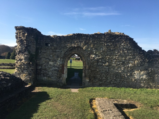

This is the first time on my walks that I’ve discovered the old ancient ruins of a building, as many of the churches I’ve walked past are still in use. Also, quite rarely, you’re able to freely walk through them and touch the stone walls and former abbey structures. Walking around it you can only imagine what it used to look like and its grand nature. If you love your historical landmarks, this is definitely worth a visit, as it has such a quirk and uniqueness about it, given that it’s only part of a landmark. It’s really amazing that this site has protected status, as it’s such a wonderful sight, and I’m sure you’d agree it would be terrible to see it removed.
There are a few photos online which provide an illustration of what the abbey looked like, and it’s such a spectacular sight, and so beautiful. It’s actually quite a shame that the abbey was pulled down, but the remains of it do mean that a part of it is still there for us to enjoy.

I’m now going to leave the Lesnes Abbey and whilst you walk out of it you get a stunning view of the woodland area once you exit the park, which highlights the scale of just how big it is.

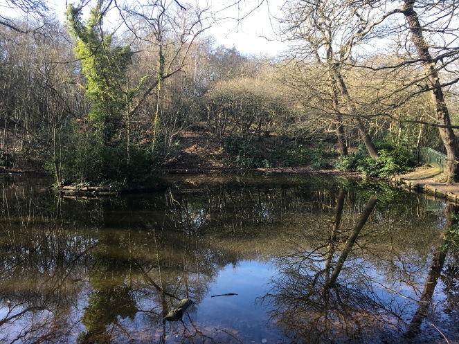
On my way to join the Thames Path I go through Birchmere Park in Thamesmead, which was a town created as part of the Greater London Council’s ‘new town’ plans, and was built over the former Erith marshes. The masterplan dates back to 1967, and was the only New Town development in Greater London. Designed to accommodate 60,000 people, Thamesmead was to have its own amenities, industry and centre with substantial areas of parkland, lakes and canals to provide a varied landscape. Today, the lake is very popular for fishing and there’s also a really cute river running through the residential area of the town.


I’d certainly love this pretty river in my neighbourhood and does remind me of many of my walks through the Regent’s Canal especially through Little Venice, Shoreditch and Mile End.


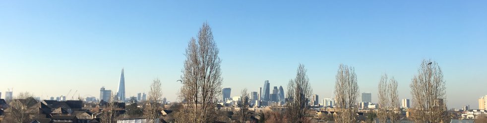
My journey now takes me to the Thames Path, as I make my way to Woolwich and the Thames Barrier. The walk on this part along the Thames really opens your eyes as to just how vast the area of the river is when you head outside of the centre of London. I think we normally think of the River Thames as being associated with areas like the Southbank, but it’s a pretty long stretch of water and does go on for quite some distance!
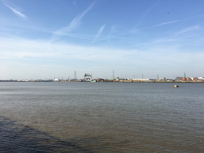
Opposite the path is North Greenwich and Beckton, and the areas are known for their high pylons as well as trading ports. Also in the far distance there are many wind turbines, which are the perfect location as they’re in a really deserted area. The view I’d admit isn’t the most picturesque you’ll see, but it does give you a flavour of a vibrant trading area where boats offload their cargo.


Walking along the path I reach my next destination of Royal Arsenal, Woolwich. The Royal Arsenal carried out armaments manufacturing, ammunition proofing and explosives research for the British armed forces. It was originally known as the Woolwich Warren, given that the land it was once on was a domestic warren in the grounds of a Tudor house. A lot of the area’s history is linked to the Board of Ordnance, which was a British Government body. They purchased the warren in the late 17th Century in order to expand an earlier base at Gun Wharf in the Woolwich Dockyard.
The next two centuries saw a growth in operations and innovations, and as a result the site expanded massively. At the time of the First World War the Arsenal covered 1,285 acres (520 hectares) and employed nearly 80,000 people. However, after this its operations were scaled down and the factory would finally close in 1967. The Ministry of Defence moved out in 1994, which would ultimately see the Royal Arsenal cease to be a military establishment.
Walking through the area today it’s an impressive housing complex of modern living and leisure space. There are reminders of the military days with a number of cannons located throughout the complex. It’s great to see that these cannons have been restored and put on display, as it’s very important that we don’t forget the past of these areas. Even though they’ve changed so much and the modern architecture is now a major part of the area, you want to know the history and background when you walk through it.


One cool and eye-catching piece of architecture is this art installation known as ‘Assembly’ which has been there since 2001 and is right next to the Royal Arsenal Woolwich pier. The 16 cast iron statues were designed by Peter Burke – and they’re quite mysterious and scary to be honest, but excellent at the same time!

Behind the statues there’s the old Riverside Guard Rooms, which has Grade II listed status.

Taking a stroll along the Thames you come to the south pier of the Woolwich Ferry which began operating in 1889. The ferry links Woolwich to North Greenwich and runs every 5-10 minutes throughout the week and every 15 minutes on the weekends. Around two million passengers use it every year, which includes pedestrians, cyclist, cars, vans and lorries. With all the bridges in London which allow us to cross the Thames, once you go past Tower Bridge there aren’t anymore bridges to cross over, so this is one of the only methods to get from one side of the Thames to the other.


I couldn’t help record the ferry crossing from one side to the other as it’s very pleasing to watch!
I also did a short timelapse video, as the ferry is very slow as you can see!
My journey will conclude at perhaps one of the most important structures in the modern era, the Thames Barrier. The barrier prevents most of Greater London from being flooded from exceptionally high tides and storm surges moving up from the North Sea. It was completed in 1982 and opened in 1984. It closes during high tide and opens during low tide to restore the river’s flow towards the sea. It’s located east of the Isle of Dogs on the northern bank of Silvertown in Newham and on the south bank of New Charlton in Greenwich.

The history of barrier dates back to a report by Sir Hermann Bondi on the North Sea flood of 1953 – which was a major flood to hit England, Scotland, Belgium and Holland – killing 2,551 people. This flood affected parts of the Thames Estuary and parts of London, and played a significant factor in the barrier being planned.
The concept of rotating gates was devised by Reginald Charles Draper who constructed a working model of a barrier in 1969. The barrier was designed by Rendel, Palmer and Tritton for the Greater London Council and was tested at the Hydraulics Research Station near Oxford. A site at New Charlton was chosen because of its straightness of riverbanks and as a result of the underlying river chalk being strong enough for the barrier. Construction of the barrier began in 1974 and was officially opened by Queen Elizabeth II in May 1984. The barriers cost £534 million (£1.6 billion today), with an additional £100 million for river defences.

The barriers are built across a 520 metre (1,706 ft) wide stretch of the river with all the gates made of steel. The gates are filled with water when they submerge and empty as they emerge from the river. Each of the four large central gates are 20.1 metres (66ft) high and weigh 3,700 tonnes each.


I’ve explored many parts of London and still have a number of areas which are on my lists of walks, but the Thames Barrier was always one of my top priorities and on the day I did this walk it was first time I’d actually been to it. It’s such an impressive and futuristic sight and you can imagine how much power and force those barriers go through to stop the water. Aside from its amazing architectural design, you can’t underestimate just how crucial these barriers are to help protect Londoners and people further afield from flooding.


Well that’s all from me on today’s walk where I’ve explored a picturesque woodland wonderland, an abbey gem, the fascinating history of Woolwich and the remarkable sight of the Thames Barrier. Hope you’ve enjoyed reading this walking adventure, and please do share your thoughts in the comments section.
Thanks for joining me and in the meantime you can follow all my walks on Twitter and Instagram, and don’t forget to sign up to my blog too so you don’t miss a post! Also why not have a read of my other walks which explore all over London, from north to south, to west to east via central, there’s something there for you! 🙂 Here are the links to them all below for you!
King’s Cross to Hampstead Heath
Leadenhall Market to Old Spitalfields Market
St Paul’s Cathedral to Moorgate
Mile End Park to London Fields
Hyde Park Corner to Italian Gardens
Clapham Common to The Albert Bridge
Grosvenor Gardens to Knightsbridge
Holland Park to Meanwhile Gardens
Hackney Downs to Springfield Park
Ravenscourt Park to Wormwood Scrubs
Covent Garden to Southwark Bridge
Putney Bridge to Barnes Common
Westminster Abbey to Vauxhall Bridge
Crystal Palace Park to Dulwich Wood
Clapham Junction to Battersea Bridge
Norbury Park to Tooting Commons
Sources:
All photos taken by London Wlogger unless stated © Copyright 2019
Information about Lesnes Abbey Wood
Information and photo about Lesnes Abbey
Information about Birchmere Park
Information about Royal Arsenal Woolwich

I’m always amazed by the woodland areas that exist with London’s boundaries. This one is beautiful and I would enjoy wandering through and then exploring the ruins of the Abbey.
LikeLiked by 2 people
With every walk I do, they seem to get better, bigger and more beautiful! The ruins of the Abbey were a particular highlight for me, just for its unique nature and something you don’t see ever in London 😃
LikeLiked by 1 person
We came across Roman ruins by accident right in the centre of London. Have you been here? https://theeternaltraveller.wordpress.com/2017/08/15/hidden-treasures/
LikeLiked by 1 person
I’ve not explored that before, but it looks really amazing and definitely the kind of gem I should feature 😃
LikeLike
How far is the walk from Abbey Wood to the Thames Barrier?
LikeLike
I’d say just under two hours 😊
LikeLike
This walk was marvelous. I enjoyed your narrative and all the photos. We didn’t see any of these things the two years we lived in Reigate.
LikeLiked by 1 person
Thank you so much Anne, so glad to hear 😃 Hopefully one day you can go back to experience them all in person!
LikeLiked by 1 person
How wonderful!
LikeLiked by 1 person
You’re so right, Cindy! Very glorious 😃
LikeLike